File:1912_Electoral_Map.png
From Wikipedia, the free encyclopedia
Size of this preview: 800 × 430 pixels. Other resolutions: 320 × 172 pixels | 640 × 344 pixels | 1,182 × 635 pixels.
Original file (1,182 × 635 pixels, file size: 86 KB, MIME type: image/png)
| This is a file from the Wikimedia Commons. Information from its description page there is shown below. Commons is a freely licensed media file repository. You can help. |
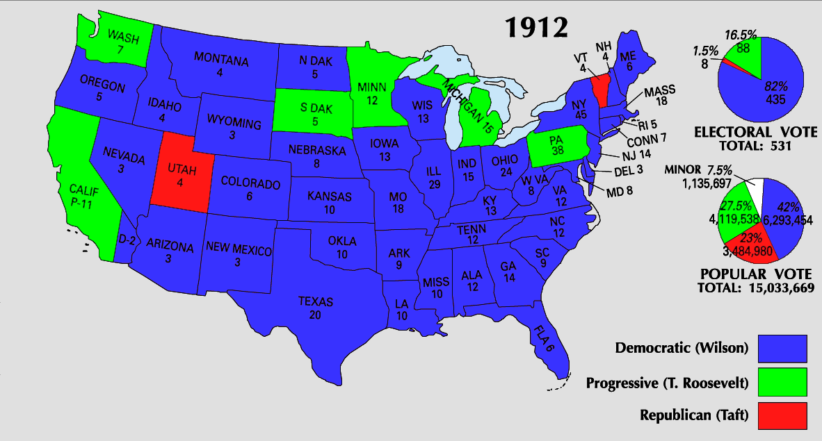
| U.S. presidential election maps from the National Atlas of the United States |
| See also: SVG maps |
| 1789 · 1792 · 1796 · 1800 · 1804 · 1808 · 1812 · 1816 · 1820 · 1824 · 1828 · 1832 · 1836 · 1840 · 1844 · 1848 · 1852 · 1856 · 1860 · 1864 · 1868 · 1872 · 1876 · 1880 · 1884 · 1888 · 1892 · 1896 · 1900 · 1904 · 1908 · 1912 · 1916 · 1920 · 1924 · 1928 · 1932 · 1936 · 1940 · 1944 · 1948 · 1952 · 1956 · 1960 · 1964 · 1968 · 1972 · 1976 · 1980 · 1984 · 1988 · 1992 · 1996 · 2000 · 2004 |
Summary


Licensing
| Public domainPublic domainfalsefalse |
This map was obtained from an edition of the National Atlas of the United States. Like almost all works of the U.S. federal government, works from the National Atlas are in the public domain in the United States.
Online access: NationalAtlas.gov | 1970 print edition: Library of Congress, Perry-Castañeda Library čeština | Deutsch | English | français | Bahasa Indonesia | italiano | македонски | മലയാളം | sicilianu | 中文 | 中文(简体) | 中文(繁體) | +/− |
Captions
Add a one-line explanation of what this file represents
Items portrayed in this file
depicts
image/png
185bfeda558236126b37b85db213d451dd059045
87,708 byte
635 pixel
1,182 pixel
File history
Click on a date/time to view the file as it appeared at that time.
| Date/Time | Thumbnail | Dimensions | User | Comment | |
|---|---|---|---|---|---|
| current | 01:43, 12 February 2009 | | 1,182 × 635 (86 KB) | Disposable.Heroes | pngcrush |
| 22:27, 25 June 2008 |  | 1,182 × 635 (179 KB) | Tallicfan20 | ||
| 23:35, 25 May 2008 |  | 1,182 × 635 (149 KB) | Tallicfan20 | distinguish the blue and green better, match bar under TR's face | |
| 04:50, 25 May 2008 |  | 1,182 × 635 (150 KB) | Tallicfan20 | better color | |
| 04:55, 17 May 2008 |  | 1,182 × 635 (103 KB) | Tallicfan20 | {{PD-USGov-Atlas}} |
File usage
The following pages on the English Wikipedia use this file (pages on other projects are not listed):
Global file usage
The following other wikis use this file:
- Usage on he.wikipedia.org
- Usage on nl.wikipedia.org
- Usage on zh.wikipedia.org
Metadata
This file contains additional information, probably added from the digital camera or scanner used to create or digitize it.
If the file has been modified from its original state, some details may not fully reflect the modified file.
| Horizontal resolution | 37.8 dpc |
|---|---|
| Vertical resolution | 37.8 dpc |
Retrieved from "https://en.wikipedia.org/wiki/File:1912_Electoral_Map.png"