File:1893_U._S._Geological_Survey_Map_of_Portsmouth_Harbor.jpg
From Wikipedia, the free encyclopedia
No higher resolution available.
1893_U._S._Geological_Survey_Map_of_Portsmouth_Harbor.jpg (800 × 600 pixels, file size: 178 KB, MIME type: image/jpeg)
| This is a file from the Wikimedia Commons. Information from its description page there is shown below. Commons is a freely licensed media file repository. You can help. |
Summary
|
This is an image of a place or building that is listed on the National Register of Historic Places in the United States of America. Its reference number is 77000141. |
| Description1893 U. S. Geological Survey Map of Portsmouth Harbor.jpg |
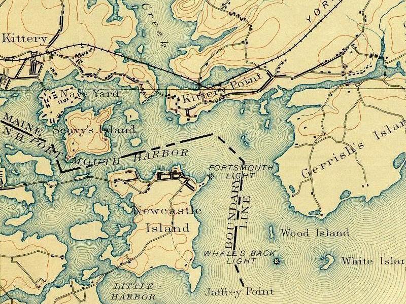
English: Portsmouth Harbor -- detail of 1893 U. S. Geological Survey map. Courtesy of the Dimond Library, Documents Department & Data Center, University of New Hampshire, Durham, NH. This shows Seavey's Island before it was conjoined with Fernald's Island, site of the Navy Yard. |
| Date | |
| Source | see above |
| Author | U.S. Geological Survey |
| Object location | 43° 04′ 59″ N, 70° 44′ 18″ W | View this and other nearby images on: OpenStreetMap |
|---|
Licensing
| Public domainPublic domainfalsefalse |
This image is in the public domain in the United States because it only contains materials that originally came from the United States Geological Survey, an agency of the United States Department of the Interior. For more information, see the official USGS copyright policy.
Bahasa Indonesia ∙ català ∙ čeština ∙ Deutsch ∙ eesti ∙ English ∙ español ∙ français ∙ galego ∙ italiano ∙ Nederlands ∙ português ∙ polski ∙ sicilianu ∙ suomi ∙ Tiếng Việt ∙ Türkçe ∙ български ∙ македонски ∙ русский ∙ മലയാളം ∙ 한국어 ∙ 日本語 ∙ 中文 ∙ 中文(简体) ∙ 中文(繁體) ∙ العربية ∙ فارسی ∙ +/− |
Wikipedia upload log
A Wikipedia description page is/was here. All following user names refer to en.wikipedia.
- 2007-09-13 15:10 Hugh Manatee 800×600× (182431 bytes) Portsmouth Harbor -- detail of 1893 U. S. Geological Survey map. Courtesy of the Dimond Library, Documents Department & Data Center, University of New Hampshire, Durham, NH.
Captions
Add a one-line explanation of what this file represents
Items portrayed in this file
depicts
1893
43°4'59.002"N, 70°44'17.999"W
image/jpeg
036d472a3e4b23e793781b7df6e9d3b17f247d4e
182,431 byte
600 pixel
800 pixel
File history
Click on a date/time to view the file as it appeared at that time.
| Date/Time | Thumbnail | Dimensions | User | Comment | |
|---|---|---|---|---|---|
| current | 03:18, 30 June 2009 | | 800 × 600 (178 KB) | File Upload Bot (Magnus Manske) | {{BotMoveToCommons|en.wikipedia|year={{subst:CURRENTYEAR}}|month={{subst:CURRENTMONTHNAME}}|day={{subst:CURRENTDAY}}}} {{Information |Description={{en|Portsmouth Harbor -- detail of 1893 U. S. Geological Survey map. Courtesy of the Dimond Library, Docume |
File usage
The following pages on the English Wikipedia use this file (pages on other projects are not listed):