File:1785_Land_Ordinance_Diagram.jpg
From Wikipedia, the free encyclopedia
Size of this preview: 603 × 599 pixels. Other resolutions: 241 × 240 pixels | 483 × 480 pixels | 773 × 768 pixels | 1,030 × 1,024 pixels | 1,800 × 1,789 pixels.
Original file (1,800 × 1,789 pixels, file size: 1.12 MB, MIME type: image/jpeg)
| This is a file from the Wikimedia Commons. Information from its description page there is shown below. Commons is a freely licensed media file repository. You can help. |
Summary
| Description1785 Land Ordinance Diagram.jpg |
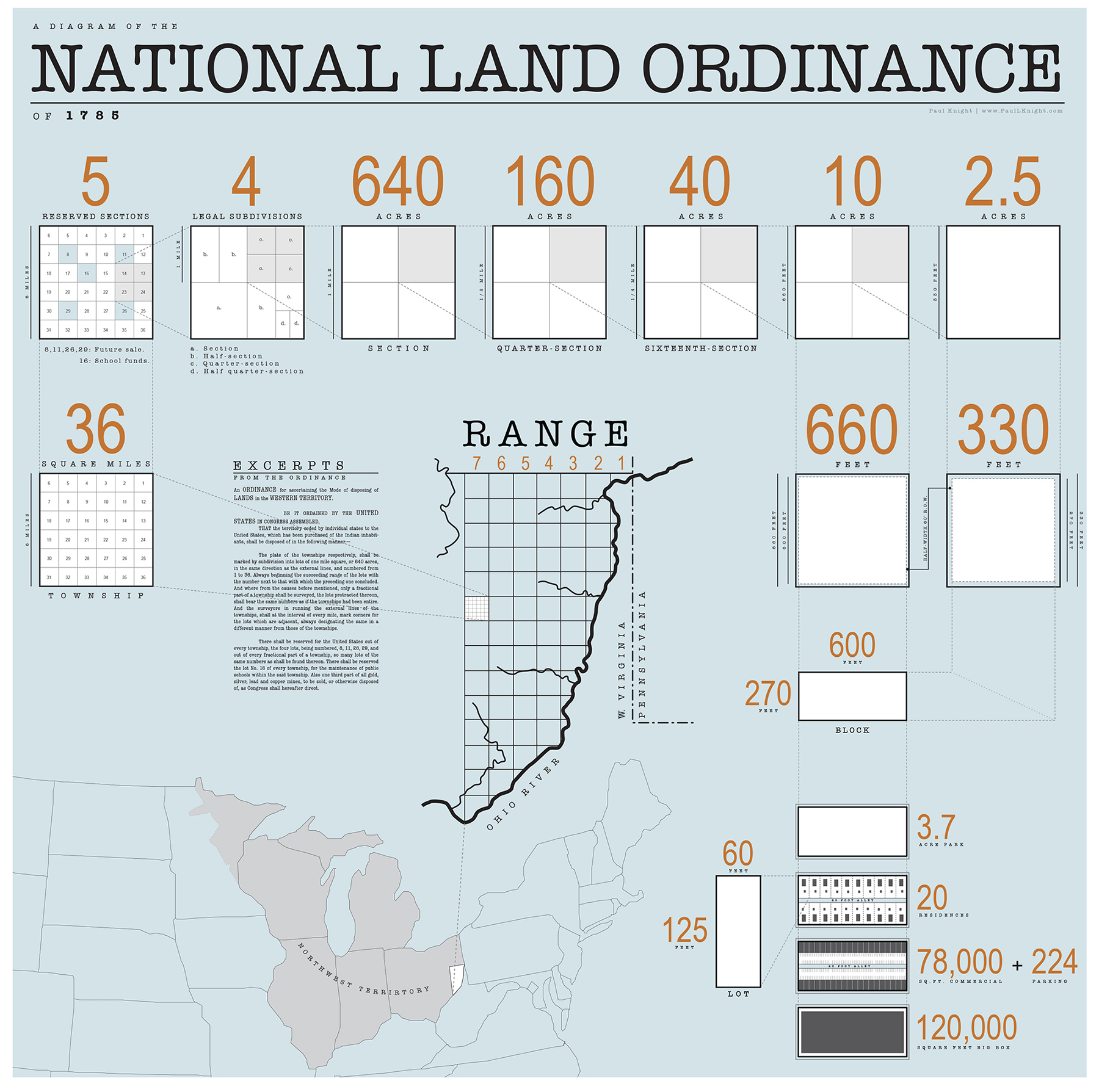
English: Diagram of the 1785 Land Ordinance showing how the method of subdivision can be applied from the scale of the country down to the scale of a single lot. |
| Date | |
| Source | Own work |
| Author | Isomorphism3000 |
Licensing
I, the copyright holder of this work, hereby publish it under the following license:
This file is licensed under the Creative Commons Attribution-Share Alike 3.0 Unported license.
- You are free:
- to share – to copy, distribute and transmit the work
- to remix – to adapt the work
- Under the following conditions:
- attribution – You must give appropriate credit, provide a link to the license, and indicate if changes were made. You may do so in any reasonable manner, but not in any way that suggests the licensor endorses you or your use.
- share alike – If you remix, transform, or build upon the material, you must distribute your contributions under the same or compatible license as the original.
Captions
Add a one-line explanation of what this file represents
Items portrayed in this file
depicts
19 November 2010
image/jpeg
bf02e827b0fa7671eb34a27070b5e98919e59ed3
1,177,515 byte
1,789 pixel
1,800 pixel
File history
Click on a date/time to view the file as it appeared at that time.
| Date/Time | Thumbnail | Dimensions | User | Comment | |
|---|---|---|---|---|---|
| current | 19:09, 31 December 2012 | | 1,800 × 1,789 (1.12 MB) | Isomorphism3000 | Fixed typo: converted "Virginia" to "W. Virginia." |
| 18:51, 31 December 2012 |  | 1,800 × 1,789 (1.12 MB) | Isomorphism3000 | User created page with UploadWizard |
File usage
The following pages on the English Wikipedia use this file (pages on other projects are not listed):
Metadata
This file contains additional information, probably added from the digital camera or scanner used to create or digitize it.
If the file has been modified from its original state, some details may not fully reflect the modified file.
| Short title |
|
|---|---|
| Width | 2,000 px |
| Height | 1,988 px |
| Bits per component |
|
| Pixel composition | RGB |
| Orientation | Normal |
| Number of components | 3 |
| Horizontal resolution | 300 dpi |
| Vertical resolution | 300 dpi |
| Software used | Adobe Photoshop CS6 (Macintosh) |
| File change date and time | 14:06, 31 December 2012 |
| Exif version | 2.21 |
| Color space | sRGB |
| Date metadata was last modified | 09:06, 31 December 2012 |
| Date and time of digitizing | 03:29, 19 November 2010 |
| Unique ID of original document | uuid:5D20892493BFDB11914A8590D31508C8 |
Retrieved from "https://en.wikipedia.org/wiki/File:1785_Land_Ordinance_Diagram.jpg"