File:1690_Coronelli_Map_of_Montenegro_-_Geographicus_-_Montenegro-coronelli-1690.jpg
From Wikipedia, the free encyclopedia
Size of this preview: 800 × 599 pixels. Other resolutions: 320 × 239 pixels | 640 × 479 pixels | 1,024 × 766 pixels | 1,280 × 958 pixels | 2,560 × 1,916 pixels | 5,000 × 3,742 pixels.
Original file (5,000 × 3,742 pixels, file size: 5.28 MB, MIME type: image/jpeg)
| This is a file from the Wikimedia Commons. Information from its description page there is shown below. Commons is a freely licensed media file repository. You can help. |
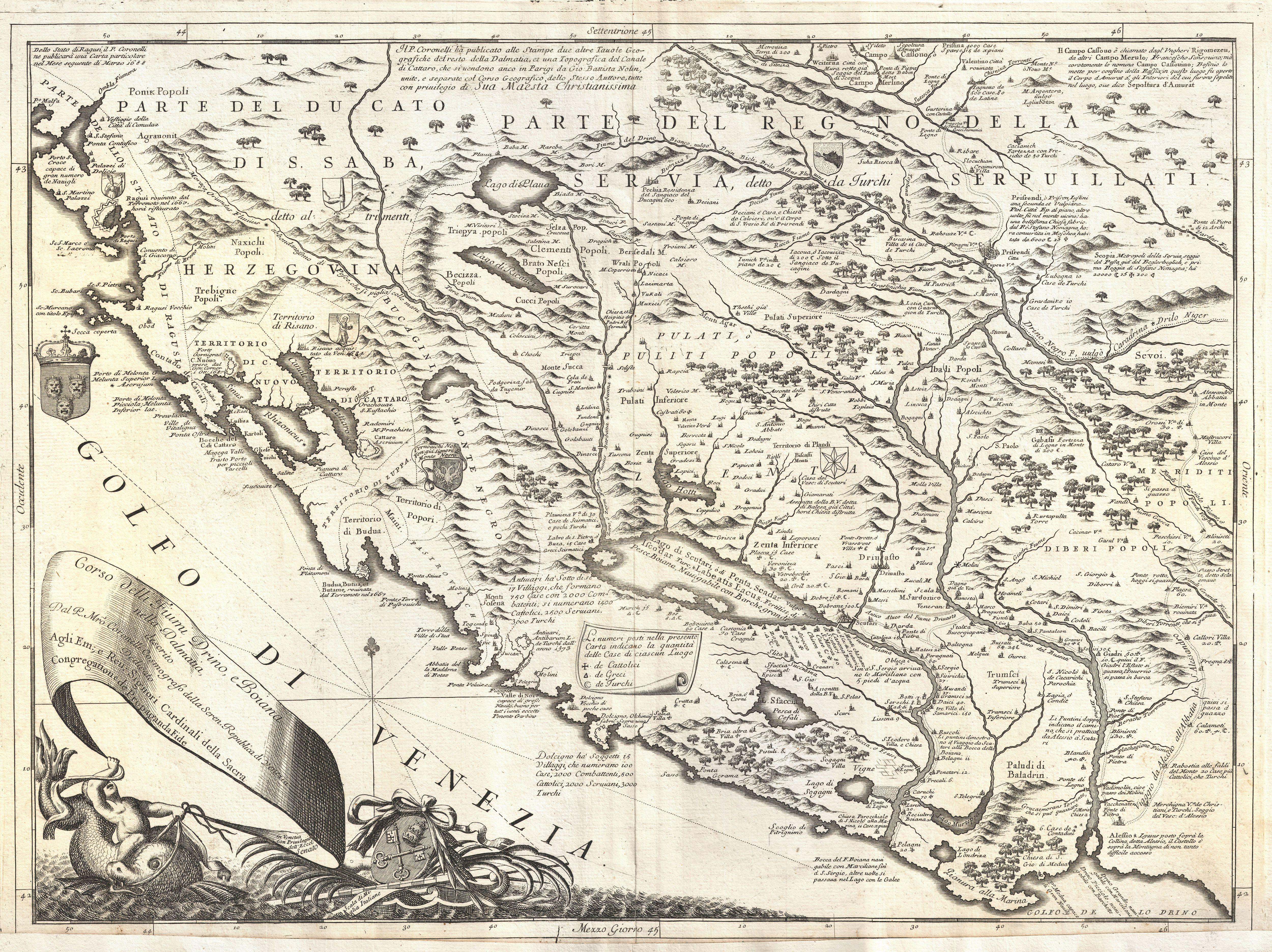
| Vincenzo Coronelli: Corso delli Fiumi Drino, e Boiana nella Dalmatia, descrito dal P. Mro Coronelli Cosmografo della Seren. Republica di Venezia dedicato - Agli Em; e Reu; Signori Cardinali della Sacra congregatione de Propaganda Fide.
( |
|||||||||||||||||||||||||||
|---|---|---|---|---|---|---|---|---|---|---|---|---|---|---|---|---|---|---|---|---|---|---|---|---|---|---|---|
| Artist |
artist QS:P170,Q561604 |
||||||||||||||||||||||||||
| Title |
Corso delli Fiumi Drino, e Boiana nella Dalmatia, descrito dal P. Mro Coronelli Cosmografo della Seren. Republica di Venezia dedicato - Agli Em; e Reu; Signori Cardinali della Sacra congregatione de Propaganda Fide. |
||||||||||||||||||||||||||
| Description |
English: This is Vincenzo Maria Coronelli's 1690 map of Montenegro. Covers the Dalmatian coast from Dubrovnik to Gjiri i Drinit, including all of modern day Montenegro as well as parts of adjacent Croatia, Albania, and Bosnia Herzegovina. Most of Coronelli's maps of the Dalmatian coast were intended to highlight the military victories of the Venetian Republic over the expansive Ottoman Turks. No exception, this map features notations throughout referring to various military battles for control of this hotly contested region. As a whole this is a splendid example of Coronelli's distinctive style at its finest, with detailed engraving, historical notes, armorial vignettes, and an elaborate title cartouche complete with a cherub riding a sea monster. Published for inclusion in Coronelli's stupendous 1690 Atlante Veneto . |
||||||||||||||||||||||||||
| Date | 1690 (undated) | ||||||||||||||||||||||||||
| Dimensions |
height: 18 in (45.7 cm); width: 24 in (60.9 cm) dimensions QS:P2048,18U218593 dimensions QS:P2049,24U218593 |
||||||||||||||||||||||||||
| Accession number |
Geographicus link: Montenegro-coronelli-1690 |
||||||||||||||||||||||||||
| Source/Photographer |
Coronelli, V. M., Atlante Veneto, 1690.
|
||||||||||||||||||||||||||
| Permission (Reusing this file) |
|
||||||||||||||||||||||||||

Captions
Add a one-line explanation of what this file represents
Items portrayed in this file
depicts
image/jpeg
000bc53653992d5e7380a18c4d91fb6d740214e7
5,536,788 byte
3,742 pixel
5,000 pixel
File history
Click on a date/time to view the file as it appeared at that time.
| Date/Time | Thumbnail | Dimensions | User | Comment | |
|---|---|---|---|---|---|
| current | 10:01, 24 March 2011 | | 5,000 × 3,742 (5.28 MB) | BotMultichillT | {{subst:User:Multichill/Geographicus |link=http://www.geographicus.com/P/AntiqueMap/Montenegro-coronelli-1690 |product_name=1690 Coronelli Map of Montenegro |map_title=Corso delli Fiumi Drino, e Boiana nella Dalmatia, descrito dal P. Mro Coronelli Cosmogr |
File usage
The following pages on the English Wikipedia use this file (pages on other projects are not listed):
Global file usage
The following other wikis use this file:
- Usage on it.wikipedia.org
- Usage on sr.wikipedia.org