| Name | Lage | Typ | Eintrag | Bild |
|---|
| Stallungen von Preston Hall |
nahe Pathhead
55° 52′ 57,4″ N, 2° 58′ 0″ W55.882611111111-2.9666666666667 |
Stallungen |
113 |
|
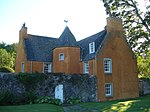
| Whitehill House |
nahe Rosewell
55° 50′ 45,8″ N, 3° 7′ 31,3″ W55.846055555556-3.1253611111111 |
Herrenhaus |
687 |
|
| North Gate |
nahe Pathhead
55° 53′ 38,1″ N, 2° 57′ 23,3″ W55.893916666667-2.9564722222222 |
Tor |
745 |
|
| Lions Gate |
nahe Pathhead
55° 52′ 34,3″ N, 2° 58′ 20,4″ W55.876194444444-2.9723333333333 |
Tor |
746 |
 |
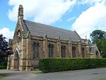
| Crichton Collegiate Church |
nahe Crichton
55° 50′ 37,4″ N, 2° 59′ 25,1″ W55.843722222222-2.9903055555556 |
Kirche |
753 |
 |
| Ford House |
Ford
55° 52′ 6,9″ N, 2° 58′ 38,8″ W55.868583333333-2.9774444444444 |
Villa |
756 |
 |
| Crichton House |
nahe Crichton
55° 51′ 6,2″ N, 2° 57′ 33,7″ W55.851722222222-2.9593611111111 |
Herrenhaus |
757 |
|
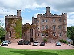
| Oxenfoord Castle |
nahe Pathhead
55° 52′ 43,4″ N, 2° 58′ 45,8″ W55.878722222222-2.9793888888889 |
Schloss |
768 |
 |
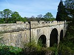
| Oxenfoord Viaduct |
nahe Pathhead
55° 52′ 46,2″ N, 2° 58′ 45,8″ W55.8795-2.9793888888889 |
Brücke |
769 |
 |
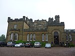
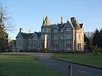
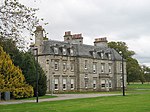
| Preston Hall |
nahe Pathhead
55° 52′ 52,1″ N, 2° 58′ 11,1″ W55.881138888889-2.96975 |
Herrenhaus |
775 |
|
| Gärten von Preston Hall |
nahe Pathhead
55° 52′ 57,7″ N, 2° 58′ 41,2″ W55.882694444444-2.9781111111111 |
Gärten |
777 |
|
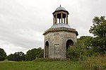
| The Temple |
nahe Pathhead
55° 53′ 13,7″ N, 2° 58′ 7,5″ W55.887138888889-2.96875 |
Mausoleum |
779 |
 |
| Cockpen and Carrington Parish Church |
Bonnyrigg
55° 51′ 58″ N, 3° 5′ 21,2″ W55.866111111111-3.0892222222222 |
Kirche |
780 |
 |
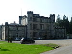
| Dalhousie Castle |
nahe Bonnyrigg
55° 51′ 38,6″ N, 3° 4′ 57″ W55.860722222222-3.0825 |
Schloss |
784 |
 |
| Vogrie House |
nahe Pathhead
55° 51′ 30″ N, 2° 59′ 26,2″ W55.858333333333-2.9906111111111 |
Herrenhaus |
799 |
 |
| Borthwick Castle |
nahe North Middleton
55° 49′ 36″ N, 3° 0′ 26,8″ W55.826666666667-3.0074444444444 |
Burg |
805 |
 |
| Middleton Hall |
nahe Middleton
55° 48′ 48,7″ N, 3° 0′ 35,8″ W55.813527777778-3.0099444444444 |
Herrenhaus |
806 |
|
| Arniston House |
nahe Gorebridge
55° 49′ 25,4″ N, 3° 4′ 39,1″ W55.823722222222-3.0775277777778 |
Herrenhaus |
808 |
 |
| Grotte von Arniston House |
nahe Gorebridge
55° 49′ 16,3″ N, 3° 4′ 49,7″ W55.821194444444-3.0804722222222 |
Grotte |
811 |
|
| North Gate-Lodge |
nahe Gorebridge
55° 50′ 22,6″ N, 3° 3′ 38,7″ W55.839611111111-3.06075 |
Wohngebäude |
814 |
|
| Gewächshaus von Dalkeith House |
Dalkeith
55° 54′ 7,7″ N, 3° 3′ 36,2″ W55.902138888889-3.0600555555556 |
Gewächshaus |
1410 |
 |
| Dalkeith House |
Dalkeith
55° 53′ 58,8″ N, 3° 4′ 4,4″ W55.899666666667-3.0678888888889 |
Schloss |
1411 |
 |
| Dark Walk |
Dalkeith
55° 53′ 51″ N, 3° 3′ 35,1″ W55.8975-3.05975 |
Tor |
1412 |
|
| King’s Gate |
Dalkeith
55° 53′ 51,5″ N, 3° 5′ 9,2″ W55.897638888889-3.0858888888889 |
Tor |
1437 |
 |
| Montagu Bridge |
Dalkeith
55° 54′ 5,5″ N, 3° 4′ 2,3″ W55.901527777778-3.0673055555556 |
Brücke |
1440 |
 |
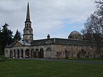
| St Mary’s Chapel |
Dalkeith
55° 53′ 52,9″ N, 3° 3′ 54,8″ W55.898027777778-3.0652222222222 |
Kirche |
1441 |
 |
| Stallungen von Dalkeith House |
Dalkeith
55° 54′ 5,9″ N, 3° 3′ 39,8″ W55.901638888889-3.0610555555556 |
Stallungen |
1442 |
|
| Glenesk Railway Viaduct |
Dalkeith
55° 53′ 33,4″ N, 3° 4′ 58,8″ W55.892611111111-3.083 |
Brücke |
1445 |
|
| Lothian Bridge |
Pathhead
55° 52′ 11,8″ N, 2° 58′ 28,6″ W55.869944444444-2.9746111111111 |
Brücke |
5090 |
 |
| Taubenturm von Mavisbank House |
Loanhead
55° 52′ 46,7″ N, 3° 7′ 48,6″ W55.879638888889-3.1301666666667 |
Taubenturm |
7386 |
 |
| Gartenhaus von Mavisbank House |
Loanhead
55° 52′ 19,5″ N, 3° 8′ 17,9″ W55.872083333333-3.1383055555556 |
Gartenhaus |
7387 |
|
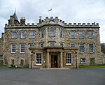
| Melville Castle |
nahe Lasswade
55° 53′ 27,6″ N, 3° 6′ 15,1″ W55.891-3.1041944444444 |
Schloss |
7394 |
 |
| Lasswade Cottage |
Lasswade
55° 52′ 52,3″ N, 3° 7′ 31,1″ W55.881194444444-3.1253055555556 |
Villa |
7398 |
|
| Mavisbank House |
Loanhead
55° 52′ 27″ N, 3° 8′ 21,5″ W55.874166666667-3.1393055555556 |
Herrenhaus |
7404 |
 |
| Glencorse Old Parish Church |
Penicuik
55° 51′ 16,7″ N, 3° 12′ 26,5″ W55.854638888889-3.2073611111111 |
Kirche |
7454 |
 |
| Glencorse Parish Church |
Penicuik
55° 51′ 3″ N, 3° 12′ 17,5″ W55.850833333333-3.2048611111111 |
Kirche |
7456 |
 |
| Bush House |
Penicuik
55° 51′ 33,2″ N, 3° 12′ 24,4″ W55.859222222222-3.2067777777778 |
Herrenhaus |
7462 |
 |
| Willie’s Temple |
nahe Rosewell
55° 53′ 23,2″ N, 3° 6′ 42,7″ W55.889777777778-3.1118611111111 |
Folly |
12940 |
|
| Hawthornden Castle |
nahe Rosewell
55° 51′ 39,2″ N, 3° 8′ 31″ W55.860888888889-3.1419444444444 |
Schloss |
13023 |
 |
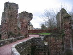
| Roslin Castle |
nahe Roslin
55° 51′ 9,4″ N, 3° 9′ 36″ W55.852611111111-3.16 |
Burgruine |
13026 |
 |
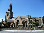
| Rosslyn Chapel |
Roslin
55° 51′ 19,4″ N, 3° 9′ 35,4″ W55.855388888889-3.1598333333333 |
Kirche |
13028 |
 |
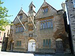
| Auchendinny House |
nahe Auchendinny
55° 50′ 22″ N, 3° 11′ 46,8″ W55.839444444444-3.1963333333333 |
Herrenhaus |
13034 |
|
| Bilston Viaduct |
Loanhead
55° 52′ 16,9″ N, 3° 9′ 3,6″ W55.871361111111-3.151 |
Brücke |
13035 |
 |
| Tor von Woolmet House |
Danderhall
55° 55′ 2,6″ N, 3° 6′ 36,4″ W55.917388888889-3.1101111111111 |
Tor |
14184 |
 |
| Newbattle Abbey |
Newbattle
55° 52′ 57,9″ N, 3° 4′ 1,2″ W55.88275-3.067 |
Herrenhaus |
14561 |
 |
| Nördliche Sonnenuhr von Newbattle Abbey |
Newbattle
55° 53′ 0″ N, 3° 3′ 58,3″ W55.883333333333-3.0661944444444 |
Sonnenuhr |
14562 |
|
| Südliche Sonnenuhr von Newbattle Abbey |
Newbattle
55° 52′ 57,7″ N, 3° 3′ 56,3″ W55.882694444444-3.0656388888889 |
Sonnenuhr |
14563 |
|
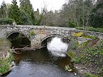
| Maiden Bridge |
Newbattle
55° 53′ 16,3″ N, 3° 3′ 42,8″ W55.887861111111-3.0619 |
Brücke |
14564 |
 |
| Monkland Wall |
Newbattle
55° 52′ 59,3″ N, 3° 4′ 13″ W55.883138888889-3.0702777777778 |
Mauer |
14566 |
 |
| Port Lodge |
Newbattle
55° 52′ 53″ N, 3° 4′ 14,6″ W55.881388888889-3.0707222222222 |
Wohngebäude |
14567 |
 |
| Newbattle Old Bridge |
Newbattle
55° 52′ 47,7″ N, 3° 4′ 12,9″ W55.879916666667-3.07025 |
Brücke |
14568 |
 |
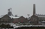
| Lady Victoria Colliery |
Newtongrange
55° 51′ 43,1″ N, 3° 4′ 3,6″ W55.861972222222-3.0676666666667 |
Bergwerk |
14604 |
 |
| Gärten von Arniston House |
nahe Gorebridge
55° 49′ 13,3″ N, 3° 4′ 42,3″ W55.820361111111-3.0784166666667 |
Gärten |
14625 |
|
| Bauernhof von Rosebery House |
nahe Temple
55° 48′ 19,2″ N, 3° 6′ 49,1″ W55.805333333333-3.1136388888889 |
Bauernhof |
14630 |
 |
| Penicuik House |
nahe Penicuik
55° 49′ 10,9″ N, 3° 15′ 2,7″ W55.819694444444-3.25075 |
Herrenhaus |
14634 |
 |
| New Penicuik House |
nahe Penicuik
55° 49′ 15,4″ N, 3° 15′ 5,2″ W55.820944444444-3.2514444444444 |
Herrenhaus |
14635 |
 |
| Gewächshaus von Fairfield House |
Dalkeith
55° 53′ 30,6″ N, 3° 4′ 10,1″ W55.891833333333-3.0694722222222 |
Gewächshaus |
24339 |
|
| St David’s Church |
Dalkeith
55° 53′ 27″ N, 3° 4′ 32,5″ W55.890833333333-3.0756944444444 |
Kirche |
24355 |
 |
| Eskbank House |
Dalkeith
55° 53′ 25,2″ N, 3° 4′ 47,3″ W55.890333333333-3.0798055555556 |
Villa |
24375 |
|
| St Nicholas Church |
Dalkeith
55° 53′ 43,6″ N, 3° 4′ 7,5″ W55.895444444444-3.06875 |
Kirche |
24377 |
 |
| Altes Rathaus von Dalkeith |
Dalkeith
55° 53′ 43,5″ N, 3° 4′ 4,2″ W55.895416666667-3.0678333333333 |
Rathaus |
24417 |
 |
| Corn Exchange von Dalkeith |
Dalkeith
55° 53′ 46,3″ N, 3° 3′ 59,5″ W55.896194444444-3.0665277777778 |
Handelsgebäude |
24422 |
 |
| Linsandel House |
Dalkeith
55° 53′ 21,7″ N, 3° 4′ 52,8″ W55.889361111111-3.0813333333333 |
Villa |
24443 |
|
| Dalkeith Lodge |
Dalkeith
55° 53′ 30,9″ N, 3° 4′ 0,5″ W55.891916666667-3.0668055555556 |
Wohngebäude |
24452 |
|
| 22–34 Bridge Street |
Penicuik
55° 49′ 28,6″ N, 3° 13′ 17,8″ W55.824611111111-3.2216111111111 |
Wohngebäude |
39294 |
 |
| Penicuik South Church |
Penicuik
55° 49′ 21,9″ N, 3° 13′ 16,2″ W55.82275-3.2211666666667 |
Kirche |
39295 |
 |
| Gärten von Mavisbank House |
nahe Loanhead
55° 52′ 25,2″ N, 3° 8′ 14″ W55.873666666667-3.1372222222222 |
Gärten |
44166 |
|
| Gefängnisturm von Glencorse |
Penicuik
55° 50′ 42,9″ N, 3° 12′ 12,1″ W55.84525-3.2033611111111 |
Turm |
44614 |
|
|


.jpg)
.jpg)


.jpg)


.jpg)


.jpg)

.jpg)


