Payl:California_map_showing_San_Diego_County.png
From Wikipedia, the free encyclopedia
Walay mas taas nga resolusyon.
California_map_showing_San_Diego_County.png (200 × 231 pixels, size sa payl: 22 KB, MIME type: image/png)
Kining maong payl gikan sa Wikimedia Commons ug mahimong gigamit sa ubang proyekto. Ang deskripsyon niini didto gipakita sa ubos.
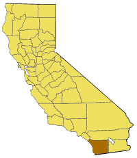
Map of San Diego county in California. From en:

|
Gitugot ang pagkopya, pag-apud-apod o/ug pag-usab ning maong dokumento ubos sa mga termino sa GNU Free Documentation License, Version 1.2 o mas bag-ong bersiyon nga gimantala sa Free Software Foundation; nga walay Invariant Sections, walay Front-Cover Texts, ug walay Back-Cover Texts. Ang kopya sa lisensiya gilakip sa bahin nga giulohang GNU Free Documentation License.http://www.gnu.org/copyleft/fdl.htmlGFDLGNU Free Documentation Licensetruetrue |
| This file is licensed under the Creative Commons Attribution-Share Alike 3.0 Unported license. | ||
| ||
| This licensing tag was added to this file as part of the GFDL licensing update.http://creativecommons.org/licenses/by-sa/3.0/CC BY-SA 3.0Creative Commons Attribution-Share Alike 3.0truetrue |
Captions
Add a one-line explanation of what this file represents
Items portrayed in this file
depicts English
copyright status English
copyrighted English
media type English
image/png
checksum English
95be53e7ecb07fe6856fe49a4f4f6396ce88e19e
data size English
22,747 byte
height English
231 pixel
width English
200 pixel
Kaagi sa payl
I-klik ang petsa/oras aron makit-an ang hulagway sa payl niadtong panahona.
| Petsa/Takna | Thumbnail | Mga dimensyon | Tiggamit | Komento | |
|---|---|---|---|---|---|
| kasamtangan | 15:25, 14 Hulyo 2005 | | 200 × 231 (22 KB) | Pyramide~commonswiki | Map of San Diego county in California. From en: {{GFDL}} Category:Maps of counties in California |
Mga paggamit sa payl
Ang mosunod nga mga panid misumpay niining payl:
Global nga paggamit sa payl
Kining ubang wiki naggamit ning maong payl:
- Paggamit sa ar.wikipedia.org
- Paggamit sa arz.wikipedia.org
- Paggamit sa ast.wikipedia.org
- Paggamit sa az.wikipedia.org
- Paggamit sa be.wikipedia.org
- Paggamit sa bg.wikipedia.org
- Paggamit sa ca.wikipedia.org
- Paggamit sa ce.wikipedia.org
- Paggamit sa cy.wikipedia.org
- Paggamit sa de.wikipedia.org
- Paggamit sa el.wikipedia.org
- Paggamit sa en.wikipedia.org
- Linda Vista, San Diego
- Mount Hope, San Diego
- Scripps Canyon
- Los Coches Creek
- Tecate, California
- Black Mountain (San Diego County, California)
- Jacumba Mountains
- Vallecito Mountains
- Santa Ysabel, California
- Balboa Park Gardens
- Tierra Blanca Mountains
- Palomar Mountain, California
- Terramar, Carlsbad, California
- Casa de Oro, California
- Pala, California
- San Dieguito County Park
- Talmadge, San Diego
- Template:SanDiegoCountyCA-geo-stub
- Proctor Valley
- San Carlos, San Diego
- Grantville, San Diego
- Oceanside Pier
- Mile of Cars
- Marina, San Diego
- Core, San Diego
- Encanto, San Diego
- Webster, San Diego
- Gateway, San Diego
- Rancho Guejito
- Middletown, San Diego
- Dehesa, California
- Hot Springs Mountain
- Batiquitos Lagoon
- Guatay, California
- Coyote Mountain (California)
- Soledad Valley
- Alvarado Estates, San Diego
- Mud Caves
- Rincon del Diablo, California
View more global usage of this file.