Restr:Allemagne_carte.png
From Wikipedia, the free encyclopedia
N'haller ket gwellaat ar pizhder.
Allemagne_carte.png (328 × 352 piksel, ment ar restr : 29 Kio, seurt MIME : image/png)
![]()
| Tennet eo ar restr-mañ eus Wikimedia Commons ha gallout a ra bezañ implijet evit raktresoù all. Diskouezet eo deskrivadur he fajenn zeskrivañ amañ dindan. |
Diverradur
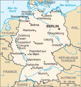
| DeskrivadurAllemagne carte.png | French map of Germany |
| Deiziad | of this version : February 2006 |
| Mammenn |
CIA World Factbook / French Wikipedia |
| Aozer | of the translations : see history file |
| Aotre (Adimplij ar restr-mañ) |
PD |
| Stummoù all | original English version : Image:Germany-CIA_WFB_Map.png |
Français : * Sujet : Carte en français de l'Allemagne ;
- Source : CIA World Factbook / Wikipédia francophone ;
- Autres versions disponibles :
- Fichier GIMP (francophone) disponible : http://fr.wikipedia.org/wiki/Image:De-map.xcf ;
- anglophone : Image:Germany-CIA_WFB_Map.png ;
- espagnol : Image:Gm-map-es.png ;
- finlandais : Image:Saksa-kartta.JPG ;
- japonais : Image:Gm-map-ja.png ;
- Auteurs des traductions : Voir l'historique ci-dessous ;
- Date : Février 2006.
File History of the French Wikipedia :
(suppr) (actu) 15 février 2006 à 21:02 . . Sting (Discuter) . . 328x352 (47 456 octets) ("Canal de Kiel" corrigé)
(suppr) (rétab) 3 février 2006 à 16:27 . . Sting (Discuter) . . 328x352 (47 058 octets) (Couleur Mer du Nord)
(suppr) (rétab) 10 janvier 2006 à 21:46 . . Truth (Discuter) . . 328x352 (45 224 octets) (carte de l'allemagne - origine https://www.cia.gov/library/publications/the-world-factbook/ archive copy at the Wayback Machine)
(suppr) (rétab) 10 janvier 2006 à 21:43 . . Truth (Discuter) . . 328x352 (45 224 octets) (carte de l'allemagne - origine https://www.cia.gov/library/publications/the-world-factbook/ archive copy at the Wayback Machine)
(suppr) (rétab) 18 septembre 2004 à 12:21 . . BernardM (Discuter) . . 328x352 (15 298 octets)
(suppr) (rétab) 18 septembre 2004 à 12:17 . . BernardM (Discuter) . . 328x352 (15 340 octets) (carte de l'Allemagne francisée)
(suppr) (rétab) 25 mai 2004 à 16:55 . . Luna04 (Discuter) . . 351x377 (25 226 octets) (carte de l'allemagne - origine https://www.cia.gov/library/publications/the-world-factbook/< {{msg:DomainePublic}})
This map was improved or created by the Wikigraphists of the Graphic Lab (fr). You can propose images to clean up, improve, create or translate as well. |
Aotre-implijout
| Public domainPublic domainfalsefalse |
This image is in the public domain because it contains materials that originally came from the United States Central Intelligence Agency's World Factbook.
Bahasa Indonesia ∙ čeština ∙ Deutsch ∙ eesti ∙ English ∙ español ∙ Esperanto ∙ français ∙ galego ∙ hrvatski ∙ italiano ∙ Nederlands ∙ norsk nynorsk ∙ polski ∙ português ∙ sicilianu ∙ slovenščina ∙ suomi ∙ Türkçe ∙ Zazaki ∙ беларуская (тарашкевіца) ∙ македонски ∙ русский ∙ српски / srpski ∙ українська ∙ ქართული ∙ বাংলা ∙ தமிழ் ∙ മലയാളം ∙ 한국어 ∙ 日本語 ∙ 中文 ∙ 中文(简体) ∙ 中文(繁體) ∙ العربية ∙ +/− |
 |
Captions
Add a one-line explanation of what this file represents
Items portrayed in this file
diskouez a ra
image/png
checksum saozneg
5e49a4dd5b009c255ba597f032e9e1b1f5cb63da
30 115 byte
352 pixel
328 pixel
Istor ar restr
Klikañ war un deiziad/eur da welet ar restr evel ma oa da neuze.
| Deiziad/Eur | Munud | Mentoù | Implijer | Notenn | |
|---|---|---|---|---|---|
| red | 17 Mez 2006 da 00:52 | | 328 × 352 (29 Kio) | Sting | {{Information |Description=French map of Germany |Source=[http://www.cia.gov/cia/publications/factbook/ CIA World Factbook]<br/>/ French Wikipedia |Date=of this version : February 2006 |Author=of the translations : see history file |Permission=PD |other_v |
Implij ar restr
Implijout a ra ar bajenn da heul ar restr-mañ :
Implij hollek ar restr
Ober a ra ar wikioù da-heul gant ar restr-mañ :
- Implij war fr.wikipedia.org
- Implij war ln.wikipedia.org
- Implij war nrm.wikipedia.org
Adtapet diwar « https://br.wikipedia.org/wiki/Restr:Allemagne_carte.png »