File:Europe_large_topographic_location_map.png
From Wikipedia, the free encyclopedia
Sınaq göstərişi ölçüsü: 771 × 600 piksel. Digər ölçülər: 309 × 240 piksel | 617 × 480 piksel | 987 × 768 piksel | 1.280 × 996 piksel | 2.334 × 1.816 piksel.
Faylın orijinalı (2.334 × 1.816 piksel, fayl həcmi: 1,19 MB, MIME növü: image/png)
| Bu fayl "Vikimedia Commons"dadır və digər layihələrdə istifadə edilə bilər. |
 |
Faylın təsvir səhifəsinə get |
Xülasə
{{Information
|description=
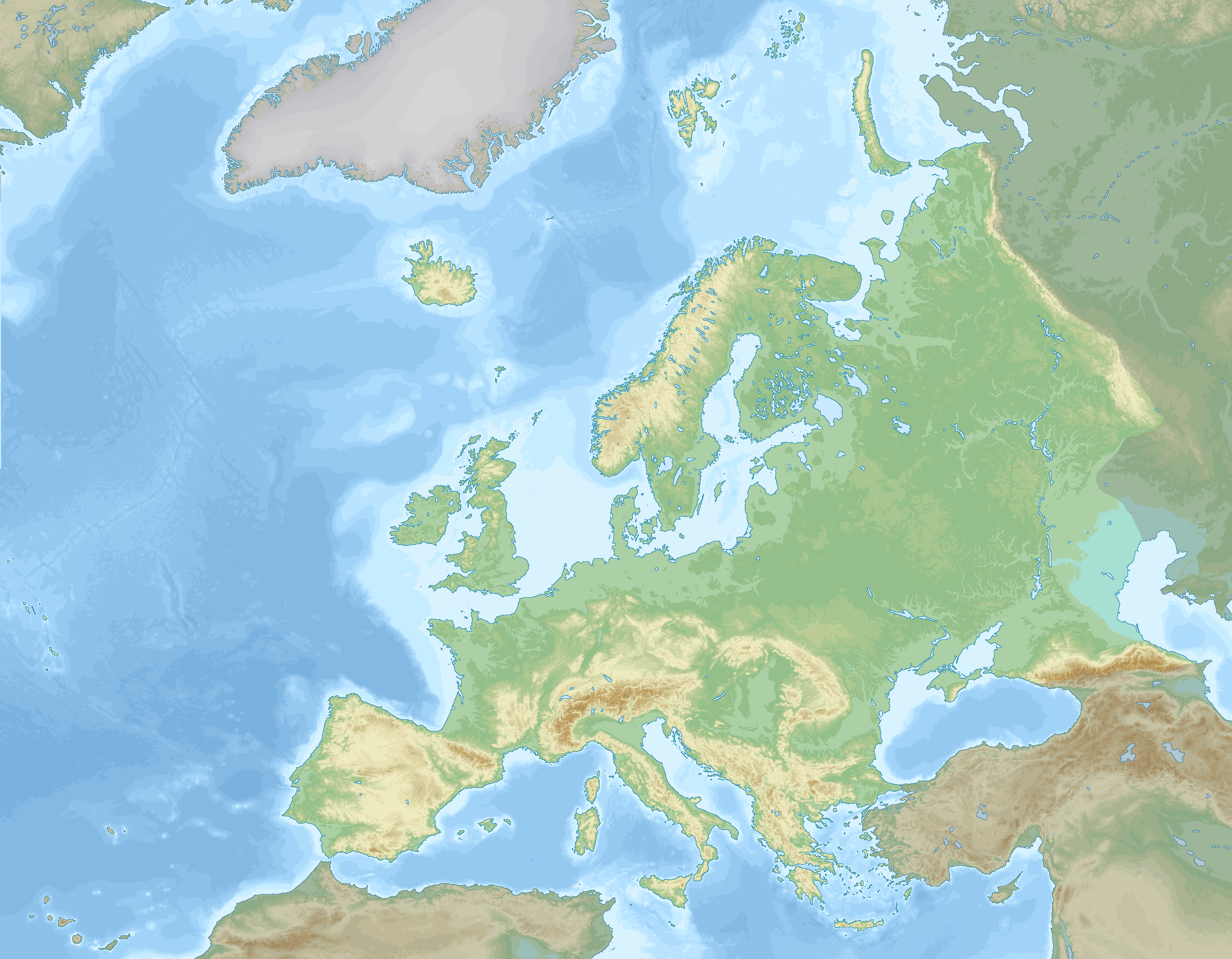
English: Location map of Europe stretching to the Canary Islands, Azores, Franz Joseph land and the entire Caucasus. A definition of Europe as bounded by the Caucasus mountains, Ural river and Ural mountains is shown.
negative
0 to 100 m
100 to 200 m
200 to 300 m
300 to 400 m
400 to 500 m
500 to 600 m
600 to 800 m
800 to 1000 m
1000 to 1200 m
1200 to 1600 m
1600 to 2000 m
2000 to 2500 m
2500 to 3000 m
3000 to 3500 m
3500 to 4000 m
above 4000 m
0 to 100 m
100 to 200 m
200 to 500 m
500 to 1000 m
1000 to 2000 m
2000 to 3000 m
3000 to 4000 m
4000 to 5000 m
below 5000 m
Data source: GEBCO 2022
Elevations (in Europe):
Sea depths:
Map Info
| Projection: | Stereographic |
|---|---|
| Projection center: | North Pole |
| Vertical meridian: | 15.000° E |
| Position of vertical meridian: | 55.4113 % of image width from left edge |
| Position of pole: | 8.9207 % of image height above top edge |
| Scale at pole: | 1.8011 % of image height ( = 1.4013 % of image width) per degree |
| x (%)= | 55.4113 + 160.5827*tan(pi*(90 - $1)/360)*sin(pi*($2 - 15)/180)
|
|---|---|
| y (%)= | -8.9207 + 206.3877*tan(pi*(90 - $1)/360)*cos(pi*($2 - 15)/180)
|
| $1: | latitude in degrees (positive for all locations on map). |
| $2: | longitude in degrees (positive or negative). |
| x (%): | x coordinate expressed as percentage of image width (measured from left edge). |
| y (%): | y coordinate expressed as percentage of image height (measured from top edge). |
Lisenziya
I, the copyright holder of this work, hereby publish it under the following license:
This file is licensed under the Creative Commons Attribution-Share Alike 4.0 International license.
- Azadsınız:
- paylaşmaq – əsəri köçürmək, paylamaq və ötürmək üçün
- remiks etmək – əsəri adaptasiya etmək
- Aşağıdakı şərtlərə riayət etməklə:
- istinad – Müvafiq kredit verməlisiniz, lisenziyaya bir keçid verməlisiniz və dəyişikliklərin olub olmadığını bildirməlisiniz. Bunu hər hansı bir ağlabatan şəkildə edə bilərsiniz, ancaq lisenziyalaşdırıcının sizi və ya istifadənizi təsdiqləməsini təklif edən bir şəkildə deyil.
- bənzər paylaşma – Əsəri remix edirsinizsə, dəyişdirirsinizsə və ya üzərində iş aparırsınızsa, öz töhfələrinizi orijinalda olduğu kimi eyni və ya uyğun lisenziya altında yayımlamalısınız.
Captions
Add a one-line explanation of what this file represents
Items portrayed in this file
təsvir edir
some value
copyright status ingilis
copyrighted ingilis
source of file ingilis
original creation by uploader ingilis
1 dekabr 2022
media type ingilis
image/png
Faylın tarixçəsi
Faylın əvvəlki versiyasını görmək üçün gün/tarix bölməsindəki tarixlərə klikləyin.
| Tarix/Vaxt | Kiçik şəkil | Ölçülər | İstifadəçi | Şərh | |
|---|---|---|---|---|---|
| indiki | 20:03, 5 sentyabr 2023 | | 2.334 × 1.816 (1,19 MB) | GrandEscogriffe | darker non-european lands; coastlines in blue |
| 18:32, 1 dekabr 2022 |  | 2.334 × 1.816 (1,17 MB) | GrandEscogriffe | Uploaded own work with UploadWizard |
Fayl keçidləri
Bu faylı istifadə edən səhifə yoxdur.
Faylın qlobal istifadəsi
Bu fayl aşağıdakı vikilərdə istifadə olunur:
- en.wikipedia.org layihəsində istifadəsi
- fr.wikipedia.org layihəsində istifadəsi
- Mer de Barents
- Mer Égée
- Dardanelles
- Nouvelle-Zemble
- Île Jan Mayen
- Rockall
- Île aux Ours
- Mer de Kara
- Liste des départements de France par altitude
- Mer Blanche
- Kolbeinsey
- Mer de Norvège
- Mer du Groenland
- Terre François-Joseph
- An Tiaracht
- Gavdos
- Cabo da Roca
- Détroit de Danemark
- Liste des provinces et territoires d'outre-mer des Pays-Bas par point culminant
- Canal de Sicile
- Capelinhos
- Cap Fligely
- Mer d'Irminger
- Baie Baïdaratskaïa
- Liste des régions et provinces d'Italie par altitude
- Mer Caspienne
- Svalbard
- Liste des cantons de Suisse par altitude
- Cap Jelania
- Bjargtangar
- Rossøya
- Mer de Sicile
- Pointe de Tarifa
- Île Victoria (Russie)
- Cap Flissingski
- Îlot de Monchique
- Vatnahverfi
- Fosse Calypso
- Liste des comtés d'Irlande par point culminant
- Liste des Länder d'Allemagne par point culminant
- Modèle:Palette Liste des points culminants des pays d'Europe
- Liste des entités de Belgique par point culminant
- Modèle:Géolocalisation/Europe 2
- Wikipédia:Atelier graphique/Cartes/Archives/décembre 2022
- Liste des provinces d'Espagne par point culminant
- Liste des fylker de Norvège par point culminant
- Liste des Länder d'Autriche par point culminant
- Liste des régions de Finlande par point culminant
Bu faylın qlobal istifadəsinə baxın.