Ficheru:North_Sea_map-en.png
From Wikipedia, the free encyclopedia
Tamañu d'esta previsualización: 479 × 600 pixels. Otres resoluciones: 192 × 240 pixels | 383 × 480 pixels | 613 × 768 pixels | 817 × 1024 pixels | 2475 × 3100 pixels.
Ficheru orixinal (2475 × 3100 píxels, tamañu de ficheru: 3,8 MB, triba MIME: image/png)
Esti ficheru ye de Wikimedia Commons y puen usalu otros proyeutos. La descripción de la páxina de descripción del ficheru s'amuesa darréu.
P
Resume
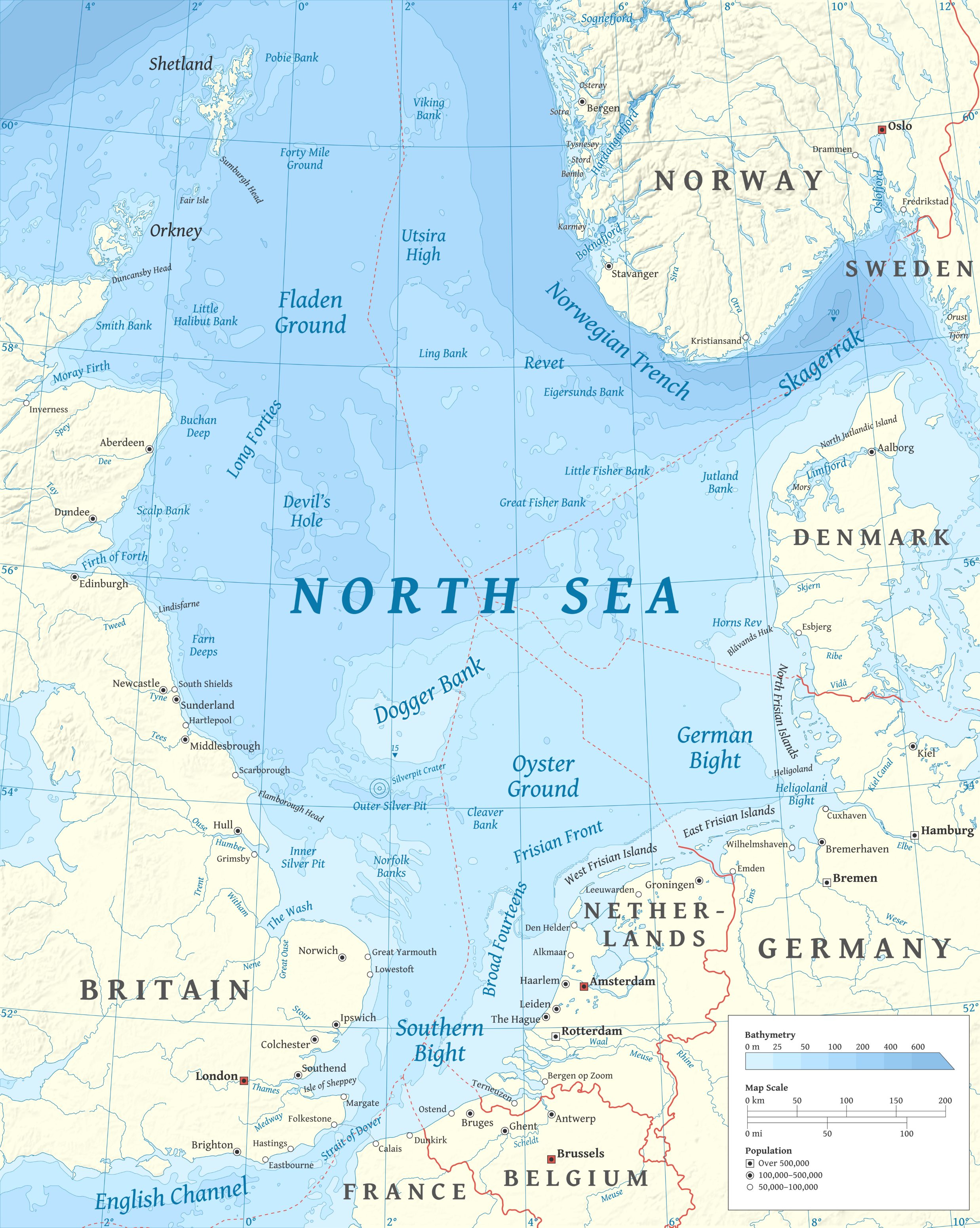
| DescripciónNorth Sea map-en.png | |
| Data | |
| Fonte |
Trabayu propiu using en:GRASS GIS, en:Inkscape and en:GIMP. Data sources:
Map Projection: Universal Transverse Mercator Typeface: Gentium Book Basic from SIL International |
| Autor | Halava |
| Otres versiones |
  |
Llicencia
Yo, el titular de los drechos d'autor d'esta obra, la espublizo baxo les siguientes llicencies:
Esti ficheru ta disponible baxo la llicencia Creative Commons Reconocimientu-Compartir igual 3.0 xenérica.
- Ye llibre:
- pa compartir – pa copiar, distribuir y comunicar públicamente la obra
- pa remezclar – p'adautar la obra
- Baxo les condiciones siguientes:
- reconocimientu – Tienes de dar el créitu apropiáu, apurrir un enllaz a la llicencia ya indicar si realizasti dalgún cambéu. Puedes faelo de cualquier mou razonable ,pero non de manera que suxera l'encontu del autor pa ti o pal usu que faigas.
- compartir igual – Si entemeces, tresformes o te bases nesti material, tienes de distribuir les tos contribuciones baxo la mesma llicencia o una compatible cola orixinal.

|
Autorízase la copia, distribución y/o cambéu d'esti documentu baxo los términos de la Llicencia de documentación llibre GNU, versión 1.2 o cualesquier otra que nel futuru espublice la Free Software Foundation; ensin seiciones invariables, testos de portada, nin testos de contraportada. S'inclúi una copia de la llicencia na seición titulada GNU Free Documentation License.http://www.gnu.org/copyleft/fdl.htmlGFDLGNU Free Documentation Licensetruetrue |
Pues seleicionar la llicencia que prefieras.
| Annotations InfoField | This image is annotated: View the annotations at Commons |
2149
2258
181
160
2475
3100
Wrongly labled. Weser is actually the Aller flowing into the Weser on the west.
Pies
Añade una explicación corta acerca de lo que representa este archivo
Elementos representados en este archivo
representa a
Algún valor sin elemento de Wikidata
6 och 2010
Historial del ficheru
Calca nuna fecha/hora pa ver el ficheru como taba daquella.
| Data/Hora | Miniatura | Dimensiones | Usuariu | Comentariu | |
|---|---|---|---|---|---|
| actual | 17:23 5 mar 2015 | | 2475 × 3100 (3,8 MB) | Tandru7 | {{Information |Description=Map of the North Sea |Source=Wiki Commons |Date=3/5/15 |Author= |Permission= |other_versions= }} |
| 14:48 15 och 2010 |  | 2475 × 3100 (3,8 MB) | Halava | New place names | |
| 17:34 12 och 2010 |  | 2475 × 3100 (3,79 MB) | Halava | Some corrections; several new place names | |
| 11:02 12 och 2010 |  | 2475 × 3100 (3,78 MB) | Halava | Minor corrections; improved legibility; Horns Rev | |
| 08:09 10 och 2010 |  | 2475 × 3100 (3,72 MB) | Halava | Exclusive economic zones; Heligoland | |
| 09:26 9 och 2010 |  | 2475 × 3100 (3,64 MB) | Halava | Lindisfarne; Norfolk Banks instead of Wells Bank | |
| 20:27 8 och 2010 |  | 2475 × 3100 (3,63 MB) | Halava | Outlined Dogger Bank, fixed a typo | |
| 17:04 8 och 2010 |  | 2475 × 3100 (3,61 MB) | Halava | Several improvements | |
| 10:52 6 och 2010 |  | 2475 × 3100 (3,37 MB) | Halava | Fixed two typos, switched color model to RGB | |
| 10:09 6 och 2010 |  | 2475 × 3100 (2,57 MB) | Halava | {{Information |Description={{en|1=Map of the North Sea.}} |Source={{own}} using GRASS GIS, Inkscape and GIMP. Data sources: * Elevation and bathymetry data from NGDC ETOPO1 * Coastlines, rivers and borders from NGDC World Data Bank II * Cities from OpenS |
Usu del ficheru
La páxina siguiente usa esti ficheru:
Usu global del ficheru
Estes otres wikis usen esti ficheru:
- Usu en af.wikipedia.org
- Usu en ar.wikipedia.org
- Usu en arz.wikipedia.org
- Usu en ba.wikipedia.org
- Usu en be-tarask.wikipedia.org
- Usu en bg.wikipedia.org
- Usu en br.wikipedia.org
- Usu en ca.wikipedia.org
- Usu en cs.wikipedia.org
- Usu en cy.wikipedia.org
- Usu en de.wikipedia.org
- Usu en de.wikivoyage.org
- Usu en el.wikipedia.org
- Usu en en.wikipedia.org
- North Sea
- Skagerrak
- SMS Lützow
- HMS King Edward VII
- HMS Marlborough (1912)
- HMS Emperor of India
- HMS Africa (1905)
- Horns Rev
- HMS Britannia (1904)
- Silverpit crater
- Broad Fourteens
- Dogger Bank
- Long Forties
- HMS Hibernia (1905)
- Fisher Bank
- Norwegian trench
- Silver Pit
- Wikipedia:Userboxes/Location
- Operation Wikinger
- HMS Commonwealth
- Northern Patrol
- Raid on Scarborough, Hartlepool and Whitby
- HMS Hindustan (1903)
- User:Buaidh
- Southern Bight
- History of the North Sea
- First Ostend Raid
- Bombardment of Yarmouth and Lowestoft
- HMS Dominion
Ver más usos globales d'esti ficheru.