Imachen:Laurasia-Gondwana-fr.svg
From Wikipedia, the free encyclopedia

Tamaño de esta previsualización PNG del archivo SVG: 519 × 435 pixels. Atras resolucions: 286 × 240 pixels | 573 × 480 pixels | 916 × 768 pixels | 1222 × 1024 pixels | 2444 × 2048 pixels.
Fichero orichinal (fichero SVG, nominalment 519 × 435 píxels, grandaria: 25 kB)
Iste fichero ye de Wikimedia Commons y pueden emplegar-lo atros prochectos. Debaixo s'amuestra a descripción d'a suya pachina de descripción.
Resumen
| DescripciónLaurasia-Gondwana-fr.svg |
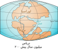
[editar] Deutsch: Die Kontinente Laurasia und Gondwana vor 200 Millionen Jahren. Eesti: Mandrid Lauraasia ja Gondwana 200 miljonit aastat tagasi. English: The continents Laurasia-Gondwana 200 million years ago. Italiano: I continenti Laurasia e Gondwana 200 milioni di anni fa. Latviešu: Laurāzijas un Gondvānas superkontinentu karte. Magyar: Laurázsia-Gondwana 200 millió évvel ezelőtt. Polski: Kontynenty Laurazji i Gondwany 200 mln lat temu. Suomi: Lauraasian ja Gondwanan mantereet triaskaudella 200 miljoonaa vuotta sitten. Svenska: Kontinenterna Laurasien och Gondwana för 200 miljoner år sedan. Türkçe: Laurasia-Gondwana.svg dosyasının türkçeleştirilmiş hali Русский: Материки Лавразия и Гондвана 200 миллионов лет назад. Српски (ћирилица): Континенти Лауразија и Гондвана прије 200 милиона година Українська: Материки Лавразия і Гондвана 200 мільйонів років тому. ქართული: ლავრაზიისა და გონდვანის ადგილმდებარეობა हिन्दी : लौरसिया-गोंडवाना महाद्वीप 200 मिलियन वर्ष पहले বাংলা : ২০ কোটি বছর আগে লরেশিয়া-গন্ডোয়ানা মহাদেশ ગુજરાતી : લોરેશિયા ગોંડવનનો નક્શો தமிழ் : புவித்தோற்றம் குறித்த ஒரு கோட்பாட்டினை விளக்கும் படம் இதுவாகும். திராசிக் நிலவியல் காலம் குறித்தவை இங்கு வரையப்பட்டுள்ளன. తెలుగు : 200 మిలియన్ సంవత్సరాల క్రితం లోర్సియా-గోండ్వానా ఖండాలు. ಕನ್ನಡ : ೨೦೦ ದಶಲಕ್ಷ ವರ್ಷಗಳ ಹಿಂದೆ ಇದ್ದ ಲಾರೇಷಿಯಾ-ಗೊಂಡ್ವಾನಾ ಭೂಖಂಡ 中文(繁體): 三疊紀海陸分布 עברית : גונדוואנה לאוראסיה العربية : قارتي لوراسيا - غندوانا قبل 200 مليون سنة |
|||
| Calendata | ||||
| Fuent |
|
|||
| Autor | Benoit Rochon, Lenny222 | |||
| Atras versions |
[editar]
|


Este mapa se ha mejorado o creado por wikigrafistas del Taller Gráfico (fr). Puedes proponer imágenes o mapas para su creación, mejora o traducción. |
Licenciando
Benoit Rochon, titular d'os dreitos d'autor d'ista obra, la publica en os termins d'a siguient licencia:
Iste fichero se troba baixo a licencia Creative Commons Atribución 3.0, Unported.
Atribución d'autoría: Benoit Rochon
- Ye libre:
- de compartir – de copiar, distribuir y transmitir o treballo
- de remezclar – d'adaptar o treballo
- Baixo as siguients condicions:
- atribución d'autoría – Ha d'atribuir l'autoría d'o treballo d'a traza especificada por l'autor u persona que l'haiga licenciau (pero no pas de traza que suchiera que l'autor/os autors refirma(n) u refirma(n) l'uso que faigas d'o treballo).
Leyendas
Añade una explicación corta acerca de lo que representa este archivo
Elementos representados en este archivo
representa a espanyol
estatus de los derechos de autor espanyol
bajo derechos de autor espanyol
fecha de fundación o creación espanyol
2 avi 2007
Historial d'o fichero
Punche en una calendata/hora ta veyer o fichero como amaneixeba por ixas envueltas.
| Calendata/Hora | Miniatura | Dimensions | Usuario | Comentario | |
|---|---|---|---|---|---|
| actual | 15:32 21 may 2009 | | 519 × 435 (25 kB) | Isaac Sanolnacov | |
| 21:08 2 avi 2007 |  | 692 × 482 (3 kB) | Brochon99 | ||
| 21:07 2 avi 2007 |  | 692 × 482 (3 kB) | Brochon99 | ||
| 21:05 2 avi 2007 |  | 692 × 482 (3 kB) | Brochon99 | == Description == {{Information |Description= {{fr|Les continents {{wfr|Gondwana}} et {{wfr|Laurasia}} au {{wfr|Trias}}, et la {{wfr|Théthys}} }} |Source= Image:Laurasia-Gondwana.png |Date= 2007-12-02 |Author= * '''Antaya on Commons |
Uso d'o fichero
A pachina siguient emplega iste fichero:
Uso de fichers globals
Os siguients wikis fan servir iste fichero:
- Uso en ar.wikipedia.org
- Uso en eu.wikipedia.org
- Uso en fr.wikipedia.org
- Uso en fr.wikibooks.org
- Uso en fr.wikiversity.org
- Uso en fr.wiktionary.org
- Uso en mg.wikipedia.org