File:Europe_large_topographic_location_map.png
From Wikipedia, the free encyclopedia
Greßi vu däre Vorschau: 771 × 600 Pixel. Wyteri Ufflösige: 309 × 240 Pixel | 617 × 480 Pixel | 987 × 768 Pixel | 1.280 × 996 Pixel | 2.334 × 1.816 Pixel.
Originaldatei (2.334 × 1.816 Pixel, Dateigrößi: 1,19 MB, MIME-Typ: image/png)
| Die Datei un d Informatione derzue were us em zäntrale Mediearchiv Wikimedia Commons (Allmänd) iibunde. | Zur Bschriibigssite uff de Allmänd |
Bschryybig
{{Information
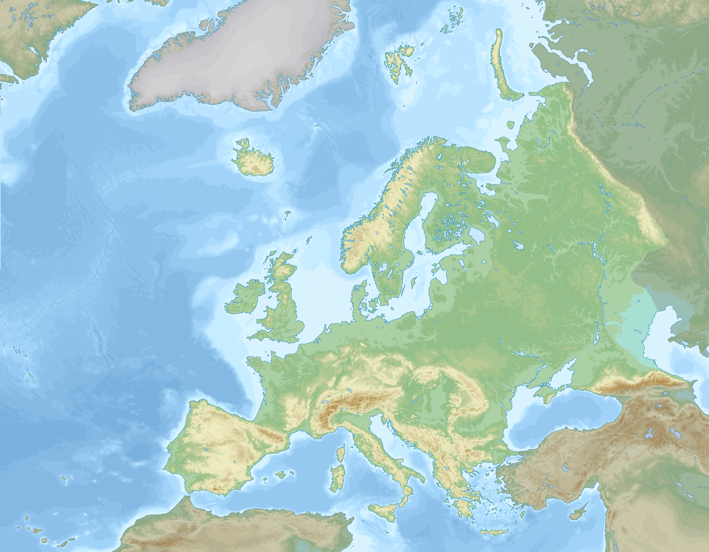
|description=
English: Location map of Europe stretching to the Canary Islands, Azores, Franz Joseph land and the entire Caucasus. A definition of Europe as bounded by the Caucasus mountains, Ural river and Ural mountains is shown.
negative
0 to 100 m
100 to 200 m
200 to 300 m
300 to 400 m
400 to 500 m
500 to 600 m
600 to 800 m
800 to 1000 m
1000 to 1200 m
1200 to 1600 m
1600 to 2000 m
2000 to 2500 m
2500 to 3000 m
3000 to 3500 m
3500 to 4000 m
above 4000 m
0 to 100 m
100 to 200 m
200 to 500 m
500 to 1000 m
1000 to 2000 m
2000 to 3000 m
3000 to 4000 m
4000 to 5000 m
below 5000 m
Data source: GEBCO 2022
Elevations (in Europe):
Sea depths:
Map Info
| Projection: | Stereographic |
|---|---|
| Projection center: | North Pole |
| Vertical meridian: | 15.000° E |
| Position of vertical meridian: | 55.4113 % of image width from left edge |
| Position of pole: | 8.9207 % of image height above top edge |
| Scale at pole: | 1.8011 % of image height ( = 1.4013 % of image width) per degree |
| x (%)= | 55.4113 + 160.5827*tan(pi*(90 - $1)/360)*sin(pi*($2 - 15)/180)
|
|---|---|
| y (%)= | -8.9207 + 206.3877*tan(pi*(90 - $1)/360)*cos(pi*($2 - 15)/180)
|
| $1: | latitude in degrees (positive for all locations on map). |
| $2: | longitude in degrees (positive or negative). |
| x (%): | x coordinate expressed as percentage of image width (measured from left edge). |
| y (%): | y coordinate expressed as percentage of image height (measured from top edge). |
Lizänzierig
Ich haa s Urheberrächt an däm Wärch un vereffetlig s dodermit unter däre Lizänz:
Diese Datei ist lizenziert unter der Creative-Commons-Lizenz „Namensnennung – Weitergabe unter gleichen Bedingungen 4.0 international“.
- Du derfsch:
- des Wärch an anderi wytergee – des Wärch kopiere, verbreite un ibertrage
- des Wärch verändere – des Wärch aapasse
- Unter däne Bedingige:
- Namenännig – Du muesch aagmässeni Aagabe zum Urheber un dr Rächt mache, e Link zue dr Lizänz zuefiege un aagee, eb Änderige gmacht wore sin. Die Aagabe chenne in ere aagmässene Art gmacht wäre, aber nit eso, ass dr Yydruck entstoht, ass dr Lizänzgeber Dii oder Dyy Gebruch vum Wärch unterstitze un guetheiße.
- Wytergab unter glyche Bedingige – Wänn du des Wärch veränderesch, umwandlesch oder druf ufböusch, no derfsch s Ergebnis nume unter dr glyche oder ere kumpatible Lizänz wie s Orginal vereffetlige.
Kurzbeschreibungen
Ergänze eine einzeilige Erklärung, was diese Datei darstellt.
Einige Werte ohne einen Wikidata-Eintrag
Urheberrechtsstatus Tüütsch
urheberrechtlich geschützt Tüütsch
Quelle der Datei Tüütsch
1. Dezämber 2022
MIME-Typ Tüütsch
image/png
Dateiversione
Klick uf e Zytpunkt zu aazeige, wie s dert usgsäh het.
| Version vom | Vorschaubild | Mäß | Benutzer | Kommentar | |
|---|---|---|---|---|---|
| aktuell | 22:03, 5. Sep. 2023 | | 2.334 × 1.816 (1,19 MB) | GrandEscogriffe | darker non-european lands; coastlines in blue |
| 20:32, 1. Dez. 2022 |  | 2.334 × 1.816 (1,17 MB) | GrandEscogriffe | Uploaded own work with UploadWizard |
Verwändig vu dr Datei
Kei Artikel bruucht die Datei.
Wältwyti Dateinutzig
Die andere Wikis bruche die Datei:
- Gebruch uf en.wikipedia.org
- Gebruch uf fr.wikipedia.org
- Mer de Barents
- Mer Égée
- Dardanelles
- Nouvelle-Zemble
- Île Jan Mayen
- Rockall
- Île aux Ours
- Mer de Kara
- Liste des départements de France par altitude
- Mer Blanche
- Kolbeinsey
- Mer de Norvège
- Mer du Groenland
- Terre François-Joseph
- An Tiaracht
- Gavdos
- Cabo da Roca
- Détroit de Danemark
- Liste des provinces et territoires d'outre-mer des Pays-Bas par point culminant
- Canal de Sicile
- Capelinhos
- Cap Fligely
- Mer d'Irminger
- Baie Baïdaratskaïa
- Liste des régions et provinces d'Italie par altitude
- Mer Caspienne
- Svalbard
- Liste des cantons de Suisse par altitude
- Cap Jelania
- Bjargtangar
- Rossøya
- Mer de Sicile
- Pointe de Tarifa
- Île Victoria (Russie)
- Cap Flissingski
- Îlot de Monchique
- Vatnahverfi
- Fosse Calypso
- Liste des comtés d'Irlande par point culminant
- Liste des Länder d'Allemagne par point culminant
- Modèle:Palette Liste des points culminants des pays d'Europe
- Liste des entités de Belgique par point culminant
- Modèle:Géolocalisation/Europe 2
- Wikipédia:Atelier graphique/Cartes/Archives/décembre 2022
- Liste des provinces d'Espagne par point culminant
- Liste des fylker de Norvège par point culminant
- Liste des Länder d'Autriche par point culminant
- Liste des régions de Finlande par point culminant
Wältwyti Verwändig vu däre Datei aaluege.