Lêer:Kiribati_map_LOC.jpg
From Wikipedia, the free encyclopedia
Grootte van hierdie voorskou: 740 × 599 piksels. Ander resolusies: 296 × 240 piksels | 593 × 480 piksels | 948 × 768 piksels | 1 264 × 1 024 piksels | 2 399 × 1 943 piksels.
Oorspronklike lêer (2 399 × 1 943 piksels, lêergrootte: 740 KG, MIME-tipe: image/jpeg)
Hierdie lêer kom vanaf Wikimedia Commons en kan ook in ander projekte gebruik word. Die beskrywing op die lêer se inligtingsblad word hieronder weergegee.

|
This locator map image could be re-created using vector graphics as an SVG file. This has several advantages; see Commons:Media for cleanup for more information. If an SVG form of this image is available, please upload it and afterwards replace this template with
{{vector version available|new image name}}.
It is recommended to name the SVG file “Kiribati map LOC.svg”—then the template Vector version available (or Vva) does not need the new image name parameter. |
 | This locator map image was uploaded in the JPEG format even though it consists of non-photographic data. This information could be stored more efficiently or accurately in the PNG or SVG format. If possible, please upload a PNG or SVG version of this image without compression artifacts, derived from a non-JPEG source (or with existing artifacts removed). After doing so, please tag the JPEG version with {{Superseded|NewImage.ext}} and remove this tag. This tag should not be applied to photographs or scans. If this image is a diagram or other image suitable for vectorisation, please tag this image with {{Convert to SVG}} instead of {{BadJPEG}}. If not suitable for vectorisation, use {{Convert to PNG}}. For more information, see {{BadJPEG}}. |  |
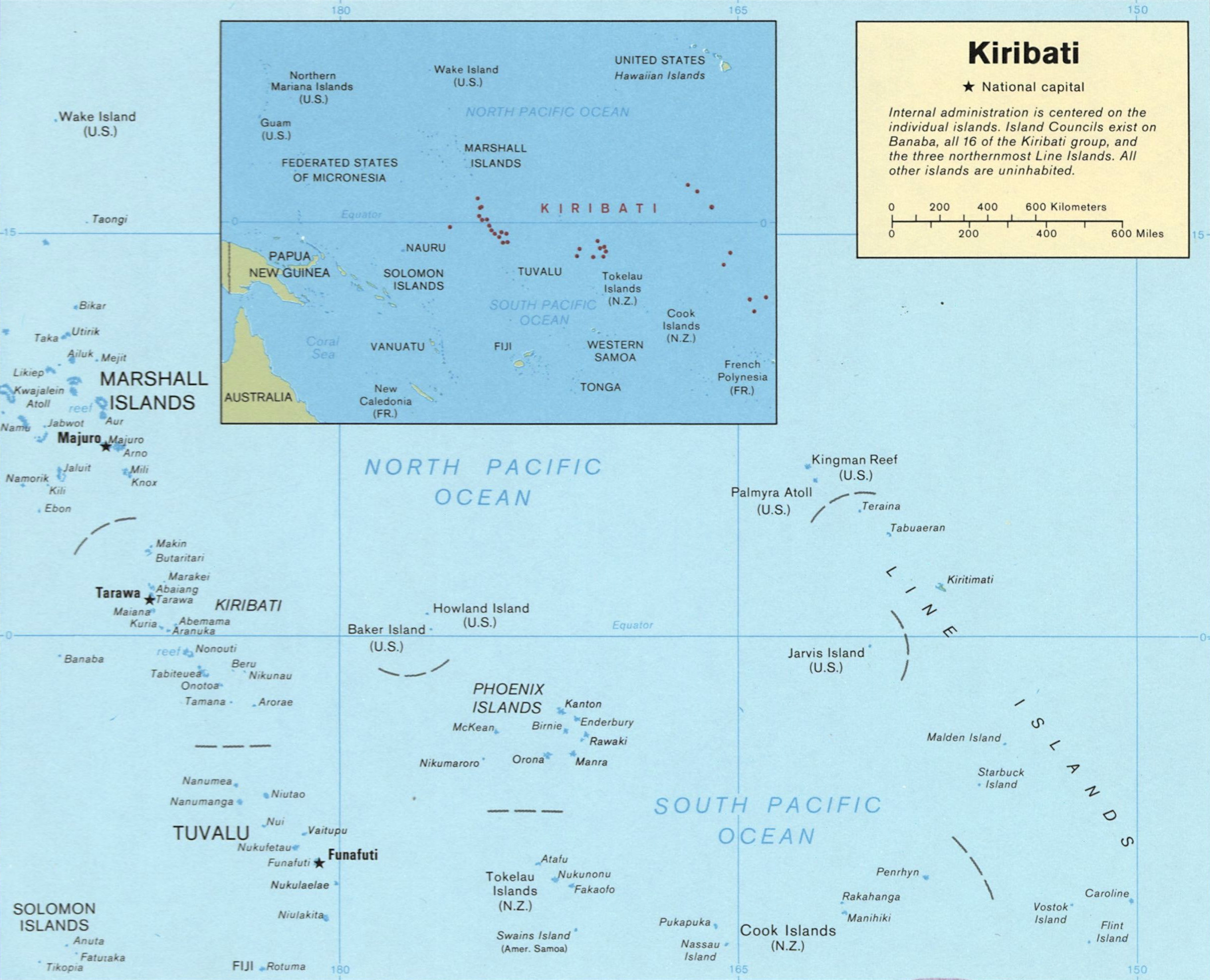
| BeskrywingKiribati map LOC.jpg |
English: Map of Kiribati
Español: Mapa de Kiribati |
||||
| Bron | http://memory.loc.gov/cgi-bin/map_item.pl?data=/home/www/data/gmd/gmd9/g9480/g9480/ct001399.jp2&style=gmd&itemLink=r?ammem/gmd:@field(NUMBER+@band(g9480+ct001399))&title=Kiribati. | ||||
| Outeur | US Dept of Congress, 1989 | ||||
| Toestemming (Hergebruik van die lêer) |
|

Lêergeskiedenis
Klik op die datum/tyd om te sien hoe die lêer destyds gelyk het.
| Datum/Tyd | Duimnael | Dimensies | Gebruiker | Opmerking | |
|---|---|---|---|---|---|
| huidig | 13:12, 15 Augustus 2010 | | 2 399 × 1 943 (740 KG) | Ras67 | cropped |
| 03:52, 19 Januarie 2008 |  | 2 417 × 1 969 (447 KG) | Indolences | {{Information |Description= ''English'': Map of Kiribati ''Español'': Mapa de Kiribati |Source= ru:Изображение:Карта Кирибати.svg |Date= |Author= US Dept of Congress, 1989 |Permission= {{PD-USGo |
Lêergebruik
Die volgende bladsy gebruik dié lêer:
Globale lêergebruik
Die volgende ander wiki's gebruik hierdie lêer:
- Gebruik in ace.wikipedia.org
- Gebruik in als.wikipedia.org
- Gebruik in ami.wikipedia.org
- Gebruik in ar.wikipedia.org
- Gebruik in bg.wikipedia.org
- Gebruik in br.wikipedia.org
- Gebruik in el.wikipedia.org
- Gebruik in en.wikipedia.org
- Gebruik in en.wikiversity.org
- Gebruik in fa.wikipedia.org
- Gebruik in fr.wiktionary.org
- Gebruik in ga.wikipedia.org
- Gebruik in id.wikipedia.org
- Gebruik in ka.wikipedia.org
- Gebruik in lfn.wikipedia.org
- Gebruik in lt.wikipedia.org
- Gebruik in mrj.wikipedia.org
- Gebruik in pl.wikipedia.org
- Gebruik in pt.wikipedia.org
- Gebruik in ro.wikipedia.org
- Gebruik in ru.wikipedia.org
- Gebruik in sk.wikipedia.org
- Gebruik in tr.wiktionary.org
- Gebruik in uk.wikipedia.org
- Gebruik in vi.wikipedia.org
- Gebruik in zh.wikipedia.org
Ontsluit van "https://af.wikipedia.org/wiki/Lêer:Kiribati_map_LOC.jpg"