Lêer:As-map.png
From Wikipedia, the free encyclopedia
As-map.png (329 × 353 piksels, lêergrootte: 21 KG, MIME-tipe: image/png)
Hierdie lêer kom vanaf Wikimedia Commons en kan ook in ander projekte gebruik word. Die beskrywing op die lêer se inligtingsblad word hieronder weergegee.

|
This map image could be re-created using vector graphics as an SVG file. This has several advantages; see Commons:Media for cleanup for more information. If an SVG form of this image is available, please upload it and afterwards replace this template with
{{vector version available|new image name}}.
It is recommended to name the SVG file “As-map.svg”—then the template Vector version available (or Vva) does not need the new image name parameter. |
Opsomming
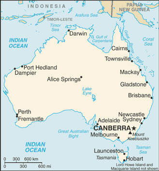
| BeskrywingAs-map.png |
Lëtzebuergesch: Kaart vun Australien. |
| Datum | 19 Julie 2007 |
| Bron |
CIA World Factbook |
| Outeur | United States Central Intelligence Agency |
| Ander weergawes |
|
.png)
Lisensiëring
| Public domainPublic domainfalsefalse |
This image is in the public domain because it contains materials that originally came from the United States Central Intelligence Agency's World Factbook.
Bahasa Indonesia ∙ čeština ∙ Deutsch ∙ eesti ∙ English ∙ español ∙ Esperanto ∙ français ∙ galego ∙ hrvatski ∙ italiano ∙ Nederlands ∙ norsk nynorsk ∙ polski ∙ português ∙ sicilianu ∙ slovenščina ∙ suomi ∙ Türkçe ∙ Zazaki ∙ беларуская (тарашкевіца) ∙ македонски ∙ русский ∙ српски / srpski ∙ українська ∙ ქართული ∙ বাংলা ∙ தமிழ் ∙ മലയാളം ∙ 한국어 ∙ 日本語 ∙ 中文 ∙ 中文(简体) ∙ 中文(繁體) ∙ العربية ∙ +/− |
 |
Captions
Items portrayed in this file
uitbeelding
19 Julie 2007
media type Engels
image/png
checksum Engels
b314a05953a561f6de2b798def83d0cbec691aab
data size Engels
21 108 greep
height Engels
353 pieksel
width Engels
329 pieksel
Lêergeskiedenis
Klik op die datum/tyd om te sien hoe die lêer destyds gelyk het.
| Datum/Tyd | Duimnael | Dimensies | Gebruiker | Opmerking | |
|---|---|---|---|---|---|
| huidig | 16:48, 28 Januarie 2009 | | 329 × 353 (21 KG) | DaniDF1995 | Reverted to version as of 16:48, 28 January 2009 |
| 16:48, 28 Januarie 2009 |  | 329 × 386 (20 KG) | DaniDF1995 | Some fix | |
| 16:48, 28 Januarie 2009 |  | 329 × 353 (21 KG) | DaniDF1995 | Reverted to version as of 16:46, 28 January 2009 | |
| 16:47, 28 Januarie 2009 |  | 329 × 386 (20 KG) | DaniDF1995 | Some fix | |
| 16:46, 28 Januarie 2009 |  | 329 × 353 (21 KG) | DaniDF1995 | Reverted to version as of 09:57, 25 July 2007 | |
| 16:45, 28 Januarie 2009 |  | 329 × 386 (20 KG) | DaniDF1995 | Some fix | |
| 09:57, 25 Julie 2007 |  | 329 × 353 (21 KG) | Hoshie | Updated map of Australia from the CIA World Factbook, 19 July 07 rev. Src: https://www.cia.gov/library/publications/the-world-factbook/maps/as-map.gif | |
| 15:07, 26 Februarie 2005 |  | 328 × 352 (13 KG) | Alfio | CIA map of Australia |
Lêergebruik
Die volgende bladsy gebruik dié lêer:
Globale lêergebruik
Die volgende ander wiki's gebruik hierdie lêer:
- Gebruik in ab.wikipedia.org
- Gebruik in arz.wikipedia.org
- Gebruik in azb.wikipedia.org
- Gebruik in bbc.wikipedia.org
- Gebruik in bg.wikipedia.org
- Gebruik in bh.wikipedia.org
- Gebruik in bjn.wikipedia.org
- Gebruik in bn.wikipedia.org
- Gebruik in ca.wikipedia.org
- Gebruik in ckb.wikipedia.org
- Gebruik in cs.wikipedia.org
- Gebruik in cv.wikipedia.org
- Gebruik in da.wikipedia.org
- Gebruik in de.wikinews.org
- Gebruik in dsb.wikipedia.org
- Gebruik in dty.wikipedia.org
- Gebruik in en.wikipedia.org
- List of cities in Australia
- Wikipedia talk:WikiProject Countries/Proposal 1
- Trans Australia Airlines Flight 538
- User:Peursem
- Outline of Australia
- Wikipedia:Recent additions/2004/April
- Module:Location map/data/Australia/doc
- User talk:Nil Einne
- Module:Location map/data/Australia
- North Australian Basin
- Gebruik in en.wikibooks.org
- Gebruik in en.wikinews.org
- Gebruik in eo.wikipedia.org
- Gebruik in es.wikipedia.org
- Gebruik in fa.wikipedia.org
- Gebruik in fi.wikipedia.org
- Gebruik in fi.wikinews.org
- Gebruik in fo.wikipedia.org
- Gebruik in fr.wikipedia.org
Wys meer globale gebruik van die lêer.